Gillygate pollution levels remain low. Congestion increasing

Not yet the rush hour, but major traffic congestion on all roads leading to Gillygate. Queued back to beyond the station to the west, beyond York Hospital to the east and to (and into) Burton Stone Lane along Bootham.

The trial metering of traffic onto Gillygate has had no material effect on air quality. Pollution levels remain very low.

NO2 levels

The York Council are apparently conducting a trial aimed at reducing the numbers of vehicles on Gillygate.

They claim to be concerned about air quality which they say is adversely impacted by queuing vehicles on the street

Despite this the authority removed posters which advised drivers to switch off engines when stationary (many cars now have an automatic stop/start feature anyway)

Pollution levels on Gillygate have edged down over the last three years.

Earlier in the year a survey revealed that about 50% of vehicle drivers had stopped their engines when in a queue. Most of those that didn’t were driving commercial vehicles or older model cars.

As the figures show, emmision levels are very low on Gillygate anyway, so why the Council would risk aggravating other road users – including bus passengers and cyclists – by imposing a “gate” restriction at the traffic lights is inexplicable. The restriction allows only small numbers of vehicles onto the street at any phase of the signals.

NO2 levels on Gillygate
York Council monitoring data

It is unacceptable for Council officials to conduct academic research exercises, which may impact on York residents lives, without prior consultation and publicity.

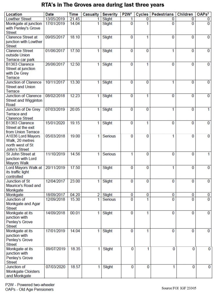
Simply shifting the traffic queues back onto Clarence Street and Lord Mayors Walk would just intensify any air quality problems for residents living in or walking down those streets.

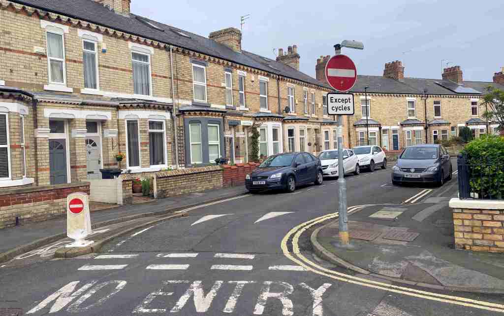
Today there are significant traffic queues on Bootham, Lord Mayors Walk and Monkgate

Pollution levels on Gillygate have reduced over the last year

Coppergate one way system set to be made permanent

In 2020 a one-way direction of travel (Piccadilly to Nessgate) was introduced on Coppergate for vehicles, except cyclists, which can travel in both directions.

Coppergate

It was controversial as it involved the re-routing of buses taking some of them further away from key destinations. The Council hasn’t yet completed a review of the impacts that the change had on bus usage and reliability but it is nevertheless planning to make the one-way system permanent

In 2021 a majority of responses to a resident consultation survey opposed the Council’s plans.

They went ahead with them anyway.

This time only a limited survey of interested parties was undertaken.

Only 6 responses were recorded.

Key conflicts between traffic and pedestrians near the entrance to the Coppergate centre remain with very narrow pavements forcing walkers onto the road.

Many will feel that the narrowness of the pavements could only be mitigated by adding that section of the street to the pedestrian area. Two-way access could be allowed at other times.

Either way, there are no easy solutions but the current set-up benefits cyclists at the expense of pedestrians, bus users. taxis and other modes of transport.

The permanent one-way system is recommended for approval at a meeting taking place next week

Green Lane/Front Street pedestrian crossing work starts on Monday

This may affect users of bus services travelling into, and from, Acomb

The pedestrian crossing at the junction of Green Lane and Front Street will be replaced with new equipment from 31st October with work taking four weeks, the road will be closed 9:30am-4pm on 2nd, 3rd and 4th November – with the rest of the time being signalled for traffic, with a temporary pedestrian crossing.

There will be a change to the layout of the crossing (as indicated on the map).

It is unclear how the now layout will help cyclists exiting Cross Street and wanting to turn right or carry on down Green Lane. The Cross Street cycle lane has formed part of the City cycle network for over 20 years.

The council says that it will be installing more reliable LED signal heads which will use significantly less electricity.

In terms of bus routes CYC’s Public Transport Planner has apparently recommended the following diversions:

  • Service 4 – turn at double roundabout on Front St and return to York via Front Street and Gale Lane.
  • Service 16 – divert via Tudor Rd, Gale Lane and terminate at Front St, turn at double roundabout and return via Gale Lane & Tudor Rd.
  • Service 24 – divert via Front St, Gale Lane and Tudor Rd.

The nearest available bus stop to be serviced by all three operators will be the stop outside Acomb Library

Council says “Final consultation is beginning on The Groves’ low traffic trial”

The Council is doing another public opinion survey on the impact of The Groves road closures.

However, no figures have been published which give an indication of the impact that closing routes through the Groves has had over the last 2 years. The trial has been dogged by delays and many of the original problems with the scheme have still to be resolved.

No safety audit was conducted before the trial began. Nor has one been published since.

Befiore and after traffic level figures on routes in and around the area were promised but nothing has emerged.

It remains unclear what the effect on emission levels has been on alternative routes although traffic has been back to its busiest for over 3 months now.

No instruments for measuring pollution levels were deployed either within The Groves or on the immediate alternative network.

Updated accident data has also not been published. The last published figures (see below) showed very low levels of accidents/collisions in The Groves itself with most problems occurring on the route onto which more traffic has now been diverted. ..

The impact on emergency services, deliveries, shops and schools remains unknown.

A Council media release reads, “A third and final consultation on The Groves’ low traffic trial will open on 22 October, and participants’ input is welcomed and will be added to a final report on the experiment.

The low traffic neighbourhood was temporarily put in place in response to local residents’ requests for better air quality, less traffic and the chance to build on the existing community spirit. Since early September 2020 when the trial began, it has been used by a wide variety of people and has been continually technically assessed.

Feedback on the trial is still being collated and now, one year on, views and experiences of the trial are being requested again to help complete the evaluation.

The findings from this survey will be reviewed alongside traffic survey data collated during the trial and other feedback received. This information will be used to prepare a report which will include a recommendation on the future of trial, which will be presented to senior councillors who will make a decision on it.

Local residents, businesses, schools, community groups and all road users are being invited to please consider the trial’s impact in more detail, and share their thoughts on it at www.smartsurvey.co.uk/s/TheGrovesLTN/ (or through the trial page at www.york.gov.uk/TheGroves).

The survey should take around 10 minutes to complete and will run from 22 October until 14 November 2021″.

“It is crucial that the measures work for all residents, businesses and community organisations in the area. We’ve been engaging closely with residents and businesses and continue to do so with this latest consultation. Please do take part in the consultation at www.smartsurvey.co.uk/s/TheGrovesLTN.”

Anyone who needs access to a computer to complete the survey can book to use one at any Explore library. Staff will be on hand to help give access to the survey online.

As an alternative to completing the questionnaire online, views on the trial can be emailed to thegrovestrial@york.gov.uk or can be posted to The Groves Trial, Network Management, City of York Council, West Offices, Station Rise, York YO1 6GA.

For more detail on the trial, visit www.york.gov.uk/TheGroves.

Have your say on improvement plans at Bootham Bar

Bootham bar photographed with the junction and traffic lights at red. Two people walk across the pedestrian junction.
Bootham Bar junction

City of York Council wants to hear what residents and businesses think of a new scheme improve pedestrian access at one of the busiest junctions in the city centre.

Works will take place later this year on the Gillygate, Bootham and St Leonard’s junction, which is all part of the Traffic Signal Asset Renewal (TSAR) Project. 

The TSAR project involves installing new signalling equipment and ducting, but also provides an opportunity to consider different options that could enhance the whole area for pedestrians and cyclists.

Two possible designs have been prepared, both would replace all the signals and increase the width of space for pedestrians waiting to cross Gillygate.

Option ‘A’ is the simplest design with little change to the existing layout while option ‘B’ would provide more pedestrian space and improve the historic setting of the area.

It would also allow for an ‘all green’ pedestrian phase across all arms of the junction, with no need to wait half way across when crossing from the Art Gallery to Bootham Bar and a less traffic dominated area.

However, the removal of the left turn lane from St Leonard’s Place to Bootham, and the changed signal phasing, would increase traffic delays and queues at peak times, with potential impact on air quality in Gillygate and Bootham.

Tell us what you think

Views are being sought on which design residents and businesses prefer and why, between Monday 1 March until Wednesday 31 March, and can be submitted, by:

  • Completing the short online survey 
  • Emailing views to: TSAR@york.gov.uk
  • Writing to: TSAR Programme, Transport Systems, Corporate Directorate of Economy and Place, West Offices, York, YO1 6GA.

In addition to the above, over 650 properties in the immediate vicinity of the junction will be sent details of the consultation and offered assistance if they cannot view the design options online.

Bishopthorpe Road closure set to continue for at least 2 months

Another behind closed doors decision by York Council

With almost breath taking arrogance, the York Council has issued a statement saying that the closure of the southbound lane at Bishopthorpe Road shops will continue for another 2 months.

There has been no debate about other options and a large petition – which asked for the road to be reopened – has been ignored.

No report on the success or otherwise of what the Council describes as a “trial” has been published.

One of the earliest criticisms of the scheme was that the Council had failed to identify how the success or otherwise of the project would actually be judged. It simply referred, rather loftily, to social distancing and government policy.

In reality, the array of bollards has made little difference to social distancing while the contraflow bike lane has introduced another, unwelcome, hazard for cyclists. There has been no consideration of opening up parallel routes (Darborough Street/Cherry Street & St Benedict’s Road) which would at least have provided a much shorter diversion

Bishopthorpe Road lane closure. Petition calls for lane to be reopened.

Nor has the opportunity been taken, during a relatively quiet period, to test an off peak pedestrianisation of the shops area between 10:30am and 4:00pm. Such a scheme would also have aligned with the governments policies while also providing much more room for social distancing. The impacts both economic and on transportation would have provided some real food for thought.

Too late now though, as imminent road works in the Nunnery Lane area are set to cause even bigger traffic congestion problems with the bus services one likely early victim. Works on the nearby South Bank flood alleviation scheme (subject to a planning committee decision next week) will further add to transport woes in the area.

Not content with increasing pollution levels on Scarcroft Road the new diversion via the City centre will add over a mile to some journeys.

The Council says that residents can Email them with their views. The address is Bishrd@york.gov.uk

We doubt that many will bother. Rather the pressure for the Council to adopt an open and inclusive approach to decision making will mount. The Council leadership needs to move out of its bunker mentality and start to re-engage with the local community.

Kent Davison Selina Meyer Gary Cole GIF | Gfycat

We saw in 2015 what happened when a particularly stubborn administration tried to force the Lendal Bridge closure on an unwilling population.

The same will happen again unless polices and attitudes change and change quickly.

Plans to widen footpaths in Piccadilly, Micklegate and Low Ousegate

The Council has belatedly published the background to its decision to  introduce a contraflow cycle route at the Bishopthorpe Road shops.

The scheme – which diverts southbound traffic onto Nunnery Lane and Blossom Street – has been criticised for increasing safety risks for cyclists. Critics also say there has been an unnecessary increase in congestion and emission levels while road works are taking place near the Holgate Road junction.

A, very thin, background report was apparently considered by the acting Chief Executive Ian Floyd on 5th May. Details have only just emerged. There was no opportunity given for public consultation on the draft proposals.

It is claimed that the change was prompted by queuing issues for pedestrians on the butchers side of the road. The Council claims that some traders were restricting the public footpath width by displaying goods outside their shops.

The report sounded the following warning, “It should be noted that where highway space is limited the provision of more space for pedestrians will reduce the space available for other modes including cyclists and/or may complicate the layout of highways – making it harder for deliveries or road users to understand and/ or navigate”.

There are Highway Maintenance works in the area which may mean that the road closure would need amending for a few nights in mid May”.

The changes cost £4000 with an ongoing weekly expenditure of £2000. The report says, “The maintenance cost could reduce if there were other traffic management schemes in the city at the same time.

It appears that no safety audit results were reported to the decision making meeting which was held in private.

The arrangement has impacted on the number 11, 26 & 21 bus services.

Tesco Express on Low Ousegate - Convenience Stores in City Centre ...
Low Ousegate

The report also says that measures may be warranted at the city centre food shops on Piccadilly, Low Ousegate and Micklegate.

Hopefully any such proposals will involve a full safety audit and consultation. Any changes in Low Ousegate in particular could have significant knock on effects on public transport.

NB. Some Labour Councillors are trying to change the policy that they advocated in January when they wanted to ban all private car use within the City walls. They now want to establish a Ultra Low Emission Zone (ULEZ) in the same area. This would allow electric car users access but would hit commercial premises deliveries, and some bus services, very hard. It is not a practical short term option.

There is a more immediate need to address the travel needs of the large number former bus users who will be excluded from that mode of travel because of ongoing social distancing rules

Don’t make it up as you go along – issues on Bishopthorpe Road

York got its first “social distancing” footpath widening on Bishopthorpe Road today. Southbound vehicles now face a 1 mile detour via Nunnery Lane and Blossom Street. It is said that this will allow those queuing outside the butchers shop to have a 2 metre social distancing space.

Maybe so.

But the execution of the project does suggest planning based on impulse rather than the result of  a more considered approach.

Northbound cycle lane closed

Not least this is because the alternative route is itself obstructed this week as extensive water company road works are take place on Blossom Street.

Blossom Street impeded by roadworks this week

Still it is even more good news for street sign manufacturers. In a week where we have seen £700,000 allocated to new City centre direction signs  and a, largely unnecessary, lamppost replacement programme eroding highway maintenance budgets still further, we now see what can only be described as a confusing forest of road closed signs appearing on Bishopthorpe Road.

Few takers for implied southbound contra flow cycle lane

The big potential losers are those who depend on two wheeled transport. The northbound cycle lane has been scrapped while an ambiguous sign on the southern approach implies that a contraflow lane is available. Not surprisingly few cyclists were today prepared to risk riding against the traffic flow on the improvised – and relatively narrow – new central carriageway. There are safer routes available via St Benedict’s Road or the Darnborough Street/Vine Street loop.

So – just as with the Lendal Bridge closure fiasco of a few years ago – the law of unintended consequences has set in on this well intentioned initiative.

Elsewhere, there are easier gains to be had. Cycle paths (and some footpaths) are once again being overgrown by weeds and bushes. A few pounds spent there would produce a better return than is evident on Bishopthorpe Road.

A trial pedestrianisation of this shopping area may well be worth considering when traffic flows have returned to normal. But everyone needs to accept that less traffic here will mean more passing vehicles in other residential areas.

The Council should spend more time ensuring that cycle paths are free of obstructions. This one on Tadcaster Road is gradually being eroded by weed growth

Thankfully the Council has put on hold its plan to stop traffic using The Groves area as a short cut. Critics of the plan pointed out that it could mean gridlock for Lord Mayors Walk with serious implications for emergency vehicle response times together with a knock on effect on public transport. Trial road closures, in the current unique circumstances, wouldn’t prove anything.

It is another scheme that needs to be re-evaluated as and when the City’s economy – and the Councils finances – return to more normal levels.