Work starts next week (17th June) between Millennium Bridge and Butcher Terrace to improve accessibility and to allow it to stay open for longer when the river levels rise.
Works will lastfor 5 weeks

News and commentary on life in and around York. Edited by Steve Galloway who represented the Westfield area on the York Council between 1973 and 2011

Work starts next week (17th June) between Millennium Bridge and Butcher Terrace to improve accessibility and to allow it to stay open for longer when the river levels rise.
Works will lastfor 5 weeks
A business in Naburn and flats in Woodsmill Quay in Skeldergate are both seeking to improving the resilience of their properties to flooding.
At Naburn, the “Tea By The Lock” restaurant – part of fhe Naburn Banqueting Hall – wants to install 2 flood barriers, automatic air bricks, non-return valves, 2 puddle pumps with hose and clips together with 2 sump pumps
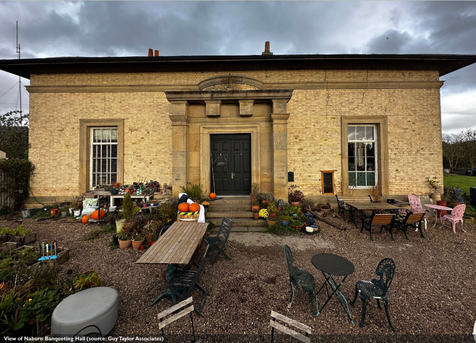
The Banqueting Hall is a Grade 11 listed building and is subject to flooding. A design and access statement (click) gives more details.

Five apartment owners at Woodsmill Quay on Skeldergate York have put forward similar flood defence proposals.
These involve external alterations including the installation of demountable flood barriers, replacement air bricks and the fitting of additional flood deterrent fixtures.
Woodsmill Quay is also a Listed Building and is vulnerable to flooding. A design and access stameent for the proposals can be viewed here (click)


Ousewem, an innovative flood resilience project, is transforming community engagement efforts by enlisting the help of talking lampposts to raise awareness about natural flood management (NFM).
Led by City of York Council, in collaboration with North Yorkshire Council, Ousewem aims to identify and deliver nature-based solutions (NbS), including NFM, to reduce flood risk in vulnerable North Yorkshire communities across Yorkshire’s Swale, Ure, Nidd, and Ouse (SUNO) river catchments.
“We’re excited to introduce cutting-edge interactive technology to increase understanding of how water is impacting our local area and community,” said Victoria Murray, Innovative Flood Resilience Project Manager, City of York Council.
As part of Ousewem’s community engagement strategy, initiatives will focus on public areas such as car parks and local pubs, distributing beer mats and signage to inform and engage farmers and residents about potential NFM projects while gathering community feedback.
The first phase of the project will see signs appearing in and around the Yorkshire Dales National Park, specifically around Hawes, Gayle and Hardraw, marking the beginning of an innovative approach to community engagement in flood resilience.
Hello Lamp Post CEO, Tiernan Mines, added,
We are thrilled to embark on this new collaboration with Ousewem, led by City of York Council.
“Together, we look forward to addressing the critical issue of flood resilience in Yorkshire. This partnership represents a powerful commitment to community engagement and environmental stewardship, and we are excited about the positive impact we can make together.”
“These interactive conversations are designed to evolve gradually over time, offering continuous educational materials, resources, and engagement opportunities,” added Murray. “We’re encouraging everyone to keep an eye out for our talking signs when out and about!”
Funded by Defra as part of the £200 million Flood and Coastal Innovation Programmes managed by the Environment Agency, Ousewem aims to drive innovation in flood and coastal resilience and adaptation to a changing climate.

It looks like the new Roomzzz Aparthotel is getting ready for business. It has submitted a series of plannng amendents as well as a plan for dealing with flooding.
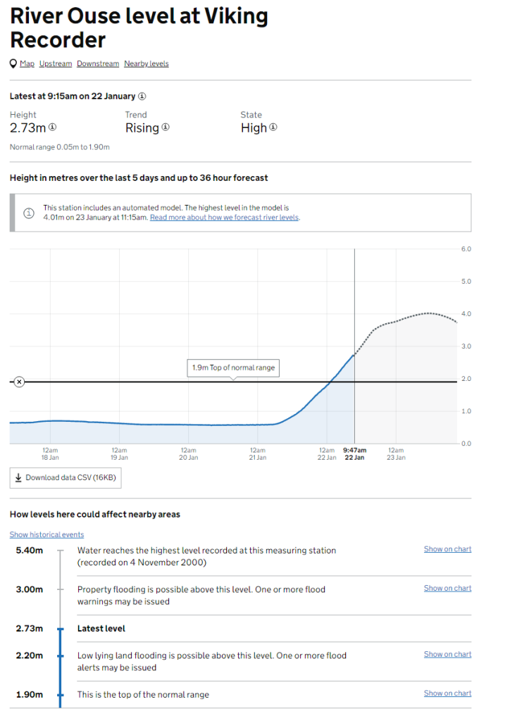
The flood plan confirms that the first floor of the building is above forecast flood levels but it acknowleges that, when Terry Avenue becomes flooded (at around 3.5 metres above normal river levels), the only access will be via the caravan site and Vine Street.
It appears that the building will be evacuated if the Envioonment Agency forecases that river levels will rise above 3.5 metres (at Viking).
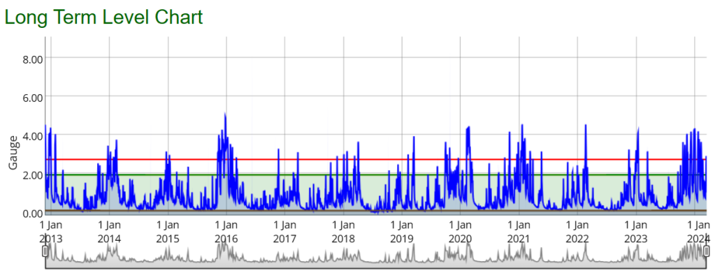
Historic river level gauge readings show that the Ouse has exceeded a height of 4 metres on at least one occasion in each of the last 5 years
The other planning applications for the development relate to changes to landscaping, glazing and signage
Update 12th Feb 2024 Problems with flooding this morning in several locations including Rawcliffe. Levels are now beginning to stabilise..


Many foot and cycle paths continue to be affected by surface water flooding today.
Some paths are closed. The cycle path near Naburn is affected (although Naburn itself hasn’t flooded).
Little rainfall is forecast for the earlier part of this week so levels show gradully fall.


Update: 1200 noon 29th Jan 2024 – Contrary to some reports , the main road through Naburn is not flooded. Howden Lane is also open. However there is alot of surface water on the approach roads to the village
Latest river level forecast. Click image to update

Update: 3:00pm 26th Jan 2024 – The main road through Naburn remains open. Howden Lane is accessible to 4×4’s. River still high.
The main road through Naburn remains open despite flooding on some paths
River levels are expected to start falling tomorrow (Thursday)


The latest period of wet weather has brought more flood alerts. Click on the graphic below to see the latest position

The flood alleviation scheme that we reported on a few weeks ago is set to get planning permission . Officers are recommending the go-ahead at a meeting next week albeit with conditions

The flood alleviation scheme comprises a pumping station and associated inlet structure, control kiosk, access track and parking area>
A culvert will run under Selby Road.
The rest of the works comprise an outfall structure and floodwall alignment and penstock across Germany Beck; two earth flood embankments, together with a temporary construction compound and tree works.
Officials are also recommending that a planning application be approved which would see the former Tramways Club on Mill Street replaced by flats. The club has been empty for several years and the area has become something of a magnet for anti-social behaviour.

Planning permission is sought for a 3-5 storey building providing 35 apartments (21 x 1 bed, 12 x 2 bed, 2 x3 bed). The developer is also proposing landscaping works to the adjacent Rest Garden. The Rest Garden is St Georges closed churchyard, and is maintained by the Council.
None of the flats would be “affordable” although a modest contribution to off-site provision is proposed
The report includes the following conclusion from officials
The site is within an area identified for regeneration in the DLP 2018 (Castle Gateway). The scheme makes effective use of land and would provide housing and these are benefits to be given substantial weight according to the NPPF.
There would not be harm to heritage assets, no undue impact on surrounding occupant’s amenity and technical issues can be addressed through conditions.
The scheme is unable to be policy compliant in terms of affordable housing provision and this has been independently verified by the Council’s district valuer. A review mechanism can be included in a legal agreement to capture any uplift in value of the scheme.
The main road in Naburn has now reopened to traffic and most of the roads in the area are dry. There is no water on the York – Selby cycle path.
However the level of the river Ouse is still high and there is a lot of water on the flood plain. Likely to be a few more days before everything is back to normal
The York – Selby cycle path is flooded near Naburn. There is about 2 inches of water across most of the path. It is still accessible with care. It is the first time we’ve seen this problem at this location (see video below)
The main street at Naburn itself (B1222) is also still blocked by flood waters. The street remains closed to traffic
River levels south of York remain high and it is likely to be several days before things return to normal. The weather forecast suggests that the showers will die out by the end of the week.


the extended period of wet weather has brought surface water flooding problems to parts of York.
Surface water accumulates when drains are either blocked or inadequate to deal with rainfall. The situation can be exacerbated if river levels are high (as they are in York at present) as this can cause a back up on pipes which drain into them.
Persistent rain means that land becomes waterlogged preventng natural soakaway. The Knavesmire is currently flooded to a level not seen since 2012.
The Council have just finished drainage improvement works on Tadcaster Road at locatiomns adjacnet to the Knavesmire

The last time major problems occured was on 13th August 2018 when a storm affected York. More than 40mm of rain fell on the city in just over 15 minutes, Rainfall rates more than 120mm/hour were recorded.
It is important that residents report problems with blocked drains and gullies. Reports can be made 24/7 via this link https://www.york.gov.uk/ReportProblems
Residents can check the level of risk to their properties from both surface water and river flooding via this link https://www.gov.uk/check-long-term-flood-risk


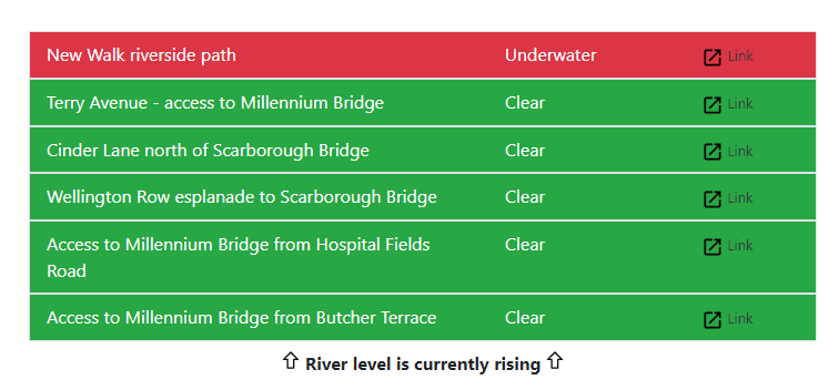
Many riverside paths remain closed due to flooding. Click image for updated figures

